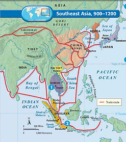
Southeast Asia
Khmer(800-1200)
Raise of Khmer Kingdom
Khmer Kingdom was in present-day Indonesia where is the mainland of S.E. Asia. By 800 A.D., Khmer Kingdom conquered neighbor countries by 1200 A.D. when they reached their peak of Kingdom.

Wikipedia. Wikimedia Foundation, n.d. Web. 06 Mar. 2016.https://commons.wikimedia.org/wiki/File:Vietnam_on_the_globe_(Vietnam_centered).svg
Agriculture
People built accurate and elaborate irrigation system and waterways to help them have 3-4 times harvest of crops per year.
Architecture
At their capital Angkor, there was an unprecedented architectural building which is Angkor Wat. This building covered almost a square mile and was also used to be an observatory because it was built on a mountain.

"Japan Team Finds Ancient Cambodian Water Site." Japan Team Finds Ancient Cambodian Water Site. N.p., n.d. Web. 06 Mar. 2016. https://khmerangkorwat21.wordpress.com/2013/06/01/%E1%9E%A2%E1%9E%84%E1%9F%92%E1%9E%82%E1%9E%9A%E1%9E%9C%E1%9E%8F%E1%9F%92%E1%9E%8F/
Sailendra
It was an agricultural Kingdom located at Java Island. Another architectural achievement that they built is a Buddhistic temple at Borobudur that was a evidence shows they traded with India by sea shipping.
"Island." : Java. N.p., n.d. Web. 06 Mar. 2016. http://letsfuntour.com/tourism-java-story.html
Srivijaya(600-1200)
A successful island empire that conquered Sailendra called Srivijaya dominated Strait of Malacca where is essential strait/path for sea trading through Eastern Asia to Western Asia. Therefore, relying on a strong trading and taxing on people wants to go pass strait of Malacca, Srivijaya got their height 7th to 13th century. Srivijaya built their capital Palembang, where was a center of learning of Buddhism, on Sumatra.
from www.classzone.com Ch 12 Sec 5
Dai Viet(935-1225)
Around 100 BC, Han Dynasty took control of North of Vietnam where is least influenced by India. At 939 Vietnamese people broke out and drove China away after Han Dynasty was weakened around 900A.D.. The Kingdom was called Dai Viet or Ly Dynasty. The ruler of Kingdom located capital at Hanoi on the Red river Delta. They kept most of Chinese government but still kept their government identified. They established a strong central government and allowed women to engage in politics to have voice, which have more freedom and independence.

Wikipedia. Wikimedia Foundation, n.d. Web. 06 Mar. 2016. http://www.wikiwand.com/ja/%E5%8D%97%E8%B6%8A%E5%9B%BD
Geograpgy of Vietnam
There are three main factors that affects which is Climate and naturalness in China. First off, climate is influential through whole China including the subsidiary of mountain system. Generally, summer is with higher and humid temperature and in contrast, winter is with colder and dryer temperature condition. This impact influences the agriculture dramatically because higher temperature and humid environment boosted crops to quicker growing tendency and more efficiently harvest per year. The Himalaya Mountain located at southwest border of China. It can block the monsoon from west and south of China to blow the wind from east to west in winter and from west to east in summer. These condition caused the typhoon every year to crush south of Chian. In addition, rivers which is Yangtse river and Yellow river which benefits the development of Chinese mainland. The modern irrigation system was built on the tank of those two essential river and fertilizes those grids in order to have great harvest.
The main source that have been using since revolution of industry is coal and woods which has high efficiency to burn. Other common mental resources are found mostly in mountain by excavating.
Resource of Vietnam
Among all the resources Vietnam has, permanent crops land occupies 12% of all land of whole country. Other common resources that they utilized is coal and oil/gasoline deposits.
Geography and Resource of Cambodia
Cambodia is located at the Indochinese peninsula. They are bound with three country: Vietnam, Thailand and Laos. Thier landscape are huge, The Lake Tonle Sap, and Mekong river surround around the country from North to South. The central plains cover the LAke Tonle Sap, and it’s the natural storage of Mekong river.
They are also border with the Gulf of Thailand, which mean they will have lots of fish. Since their areas is surrounding the Mekong river, they will have fertile land and it’s great for farming. The central of their country have commercial manganese, phosphate and deposits of salt.
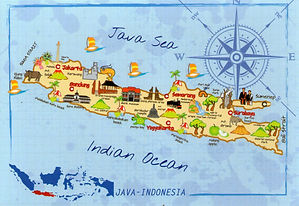
Geography and Resource of Indonesia
Indonesia contains about 1700 islands, near equatorial. The biggest islands are the Java, Kalimantan, Sumatra and so on. Their region include rain forest, and lots of mountainous, and several active volcanoes. They have numerous population, which is the world’s fourth nation for population.
Since they are made of large amount of archipelago, they must really good at fishing. They have lots of natural resources, especially tin, they provides 20% of the world’s tin. They have a large amount of copper, nickel, gold and coal resources. The petroleum and minerals also has considerable amount.
Geography and Resource of Malaysia
There are two part of Malaysia, Peninsular Malaysia and East Malaysia. The Peninsular Malaysia is part of the Southeast Asia, and the East Malaysia is in the states of Sabah and Sarawak. They are bound with Indonesia and Thailand. The coastal plains that they have covered with grumous rain forests and some mountains.
Just like Indonesia, they also has large deposits of tin. Since they are covered with the rainforest, they have large numerous rubber trees. Beside those, they also have some minerals such as copper, uranium, Palm oil, Timber, Petroleum and Natural Gas.
Work Citation
Wikipedia. Wikimedia Foundation, n.d. Web. 10 Mar. 2016.https://en.wikipedia.org/wiki/Geography_of_Vietnam
"Cambodia Geography - About Cambodia | Tourism Cambodia." Tourism of Cambodia. N.p., n.d. Web. 10 Mar. 2016. http://www.tourismcambodia.com/about-cambodia/geography.htm
"Indonesia Facts, Indonesia Flag -- National Geographic." National Geographic. N.p., n.d. Web. 10 Mar. 2016. http://travel.nationalgeographic.com/travel/countries/indonesia-facts/
"Natural Resource Governance Institute." Indonesia. N.p., n.d. Web. 10 Mar. 2016. http://www.resourcegovernance.org/our-work/country/indonesia
"Malaysia Geography." Geography of Malaysia, Landforms. N.p., n.d. Web. 10 Mar. 2016. http://www.worldatlas.com/webimage/countrys/asia/malaysia/myland.htm
"Malaysia Natural Resources." Malaysia Natural Resources. N.p., n.d. Web. 10 Mar. 2016. http://www.slideshare.net/Javaid.pugc/malaysia-natural-resource.